
 |
| This type of aerial photograph was popular in the 1950's and 1960's. Potential customers were contacted, and if interested, could have an aerial photograph of their homestead, for a price. |
Aerial photographs were briefly mentioned in the 17 December 2015 post on Historic Home Research.
But today we are going to look more closely at the historic aerial photographs in the Franklin Sylvester Room at the Medina Library.
All of the aerial photos belonged to the Natural Resource Conservation Service/Farm Service Agency (FSA) USDA. When they moved their offices back in the seventies they were going to throw them out and the Soil and Water Conservation District saved them. Later, they did not have a place to store them so the Library took them off their hands. The FSA uses on line aerial now and newer images can be purchased at their web site Farm Service Agency
The photos are useful to researchers because they can help pinpoint how a piece of land has been used over the years or narrow down when a particular house or development was constructed. If the scale is large enough, you might be able to make out details of buildings.
As an example, we will take a look at a particular street in the city of Medina - West Park Boulevard - which happens to be where I live.
With this type of research, as with family history research, you want to start with what we know now and work our way into the past.
HOWEVER, today, we will start with a look at what the neighborhood looks like today and then jump to the oldest record, 1937, and work toward the present.
HOWEVER, today, we will start with a look at what the neighborhood looks like today and then jump to the oldest record, 1937, and work toward the present.
For comparison, we will look at the street today using Google Maps.
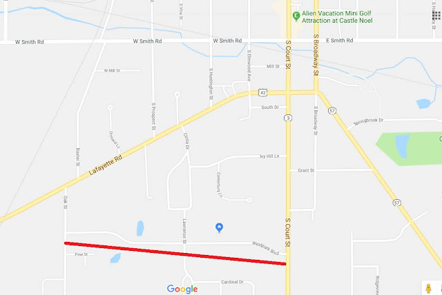 |
In this screen shot from Google Maps, West Park Blvd. is right above the red line. It is south west of Medina Square and runs between South Court Street on the east, and Oak Street on the west. It is an older tree-lined neighborhood.
 |
The oval in the upper left is the track at the fair grounds. While there is a 2018 copyright date on this photo, I know for certain that it is at least 1 year older than that. If you look at the Street View, it is from July of 2013.
So that is how the neighborhood looks today. And with Google Maps you can zoom in very close.
But how did it look in the past? City and county directories and plat maps can only give you a map. The aerial photographs give you a picture!
Aerial Photographs
The Medina Library has Aerial Photograph sets that cover these years:- 1937
- 1950
- 1958
- 1965
- 1973
- 1979
Notice that there is nothing from the 1940's? America was busy fighting a war from 1941-1945. IF any photographs were taken, it is likely they would have been destroyed or classified, so they couldn't get into enemy hands. More likely, they just weren't taken.
Each set has a Key that is a map of Medina County. Handwritten across the map are numbers that correspond to the appropriate photograph.
Here is the key for the 1937 set:

Here is the key for the 1937 set:
 |
By looking at the area on Google Maps and comparing it to the Key, we know to look for the
photo marked 12-1087.
The actual photo measures 9 inches X 9 inches, so if you didn't bring a magnifying glass with you, ask to borrow one from the Library.
Here is the area of West Park enlarged:
As you can see, the area is mostly farmland with veryfew landmarks to help orient ourselves.
Here is the area of West Park enlarged:
 |
 |
81 years ago, the City of Medina was concentrated around the Square and a few blocks in any direction. The area that is now in the West Park neighborhood was still part of Montville Township and was predominately farmland. You can even see the dotted patches of the apple orchards that older residents say were in the area.
Here is the same area from the 1950 set of Aerial Photographs:

West Park is a relatively new street here with just a few houses on it. Oak Street, on the western (left) end of West Park has a lot more houses, but seems to lead into an area of construction. There are still plenty of agricultural fields both to the north (above) and the south (below) West Park.
The photograph from the 1958 set:
 |
But notice the gap under the red X? According to the Medina County Auditor's web site, that house was built in 1966.
There is still a lot of open space east and west of Circle Drive. And look at the open field south of West Park!
Here is part of the key to the 1965 set:

It is only by comparing the surrounding numbers that we are able to make out that the photo for the West Park neighborhood should be marked 3-87.

There aren't a lot of changes visible in this photo, but just out of the frame, below the word "Park" there is a major addition - The Ella Canavan Elementary School. The school opened in 1960.
The 1973 and 1979 sets are 2' X 2' and share the same Key. Originally, someone had handwritten the numbers across the map. Then someone else covered over the handwritten key codes with raised letters. The letters have started falling off, but you can still read the handwriting underneath.

An excerpt from the 1973-79 key indicating that the photo we want is I-6.

Here is a blow up of the West Park neighborhood from the 1973 key:

Notice the development to the north of West Park and to the East of Circle drive. Medina, and this neighborhood, were definitely growing!
This is a blow up from I-6 Photo from the 1979 Set for the West Park Blvd. area with some of the familiar landmarks typed in.

Combine Aerial Photograph research with city and county directories and Sanborn Fire Insurance Maps and you can get a pretty detailed picture of the development of neighborhoods and cities.
The U.S. Geologic Survey has historic aerial photographs online at Earth Explorer. However, today this message appeared:
The Department of the Interior and the USGS have requested a Federal Advisory Committee to review USGS’s current free-and-open policy for user access to Landsat data.
This USGS web page provides a synopsis of frequently-asked questions and answers about the ongoing review.
2 comments:
Thanks, Kathy, for more outstanding research. Very helpful in putting these different map and photo resources to good use.
I like this article.I read your message at the end. When I went to website EarthExplore and typed in Medina County, Ohio, it showed the coordinates and location on Google map Step 1. But I don't know how to get the aerial photos. I would like to find photos of the Spencer area. Here is another website of aerial photos I found: https://vintageaerial.com/photos/ohio/lorain/search?utf8=%E2%9C%93&type=address&lat=41.10033&lng=-82.12321&q=Spencer%2C%20OH%2044275%2C%20USA&commit=Show%20Nearby%20Photos
Thanks for posting
Post a Comment